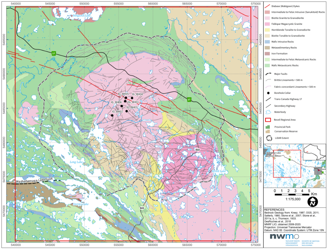
The Nuclear Waste Management Organization’s (NWMO) recent studies deepen our understanding of the geology in the Ignace area and surrounding region.
A recently published series of reports document our understanding of the regional geology as we continue our work towards confirming if the Ignace area is a suitable site for a deep geological repository.
The Ignace area, along with South Bruce, Ont., is one of two locations the NWMO is considering as potential hosts for the repository – a repository that will be designed to safely contain and isolate Canada’s used nuclear fuel in a manner that protects people and the environment for generations to come.
“Results from these integrated studies provide a foundation for understanding the regional geology and are a very important stepping-stone for the other work we do,” said Andy Parmenter, Section Manager for the Geoscientific Integration and Synthesis team at the NWMO, who led the team that drafted the three reports.
This work strengthens our understanding of the bedrock geology of the Revell batholith – the rock formation at the potential site – near Ignace. Other work by our geoscience team such as ongoing borehole drilling activities will continue to advance this understanding.
Work by the NWMO’s Geoscientific Integration and Synthesis team
One of the new reports presents an updated bedrock geology map for the Revell batholith and surrounding areas. The authors drew on aerial surveys, field mapping data gathered on the ground, and information from historic bedrock geology maps of the area to produce this updated map.
The authors sought to integrate all that complex information into a technically comprehensive, yet still visually appealing image.
“A geological map needs to tell a complex story in a simple manner,” said Lindsay Waffle, a geologist at the NWMO who worked on developing the overall presentation and layout of the map.
‘A detailed picture’ of subsurface geology
The NWMO and our contractors were able to take this understanding further. Using the updated map, as well as data from geophysical surveys, we were able to generate a 3D image of the Revell batholith and surrounding rock units.
“This information provides the NWMO a detailed picture of the subsurface geology in the region,” said Dr. Aaron DesRoches, Senior Geophysicist at the NWMO.
To better understand potential pathways for groundwater flow, a team of NWMO geoscientists also completed a detailed lineament (or geological feature) interpretation for the Revell batholith and surrounding rock units using the available geophysical and remote sensing data.
“Interpreted lineaments represent areas of the bedrock that may contain fractured pathways for water to flow,” said Dr. DesRoches.
“Using the most accurate bedrock geology and lineament data is a key step in understanding the potential suitability of the lgnace area for implementing Canada’s plan for the safe, long-term storage of used nuclear fuel inside a deep geological repository,” said Dr. DesRoches. “These recent and older studies, combined, paint a picture of what the area is like, both at the surface and deep underground.”
About the NWMO
The Nuclear Waste Management Organization (NWMO) is a not-for-profit organization tasked with the safe, long-term storage of Canada’s used nuclear fuel in a manner that protects people and the environment for generations to come.
We are implementing Canada’s plan to safely contain and isolate used nuclear fuel inside a deep geological repository. The plan is based on years of public input, Indigenous Knowledge, international scientific consensus, and best practices from around the world.
Canada’s plan will only proceed in an area with informed and willing hosts, where the municipality, First Nation and Métis communities, and others in the area are working together to implement it. The NWMO plans to select a site in 2023, and two areas remain in our site selection process: the Ignace area and South Bruce, both in Ontario.
Transparent and accountable, the NWMO works in close co-operation with communities, all levels of government, national and international regulators, Indigenous peoples, industry, academia, and civil society organizations.

